London Nocturnal Urban Archive Diorama
GPT Image 2 promptsGPT Image 2 prompt examplesGPT image promptsAI prompt examplesAI image prompt examplesOpenAI image generation promptsChatGPT image promptsprompt library
Full GPT Image 2 Prompt
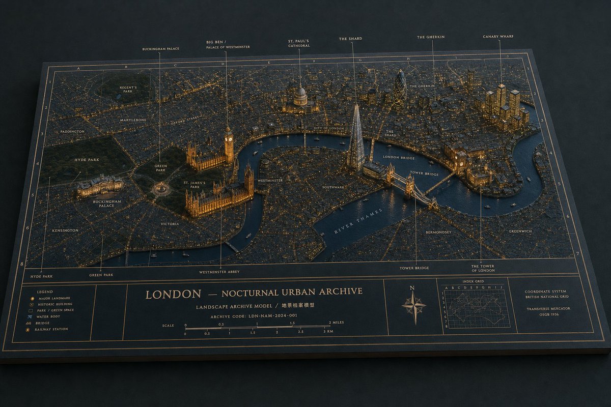
Goal: Create a cinematic physical museum-diorama map titled {argument name="city title" default="LONDON — NOCTURNAL URBAN ARCHIVE"}, showing London at night as a raised 3D architectural archive model on a flat cartographic board.
Canvas: Wide horizontal 16:9 image, three-quarter overhead perspective, the entire board visible on a dark matte tabletop. Use a restrained nocturnal palette: deep navy paper, charcoal streets, warm amber city lights, muted gold cartographic lines, dark blue water, and subtle off-white typography.
Main scene: Build a detailed miniature relief map of central London with the River Thames curving across the lower-middle and right side. Streets should appear as dense fine-line grids with thousands of tiny warm lights. Parks are dark green recessed areas. Buildings are low matte extrusions with key landmarks rising taller and more sculptural. Make the model feel tactile and physical: paper grain, beveled board edges, cast shadows, tiny boats on the river, and realistic museum-display lighting.
Landmarks and callouts: Include exactly 6 vertical top annotation callouts with thin gold leader lines and small uppercase labels: 1) Buckingham Palace, 2) Big Ben / Palace of Westminster, 3) St. Paul's Cathedral, 4) The Shard, 5) The Gherkin, 6) Canary Wharf. Place them left to right across the top border. Represent the Palace of Westminster and Big Ben near the Thames with warm illumination, St. Paul's with a glowing dome, The Shard as a tall sharp glass spire, The Gherkin as a rounded bullet-shaped tower, Canary Wharf as a cluster of golden high-rises, and Tower Bridge as a lit bridge crossing the Thames.
Map labels: Add small uppercase neighborhood and place labels directly on the map, including Regent's Park, Marylebone, Oxford Street, Paddington, Hyde Park, Green Park, St. James's Park, Buckingham Palace, Kensington, Victoria, Westminster, Southwark, City of London, London Bridge, Tower Bridge, Bermondsey, Greenwich, River Thames, The Shard, The Gherkin, and The Tower of London. Use subtle cream or pale gold type that follows the archival map aesthetic.
Grid and border system: Overlay a precise atlas-style index grid with letters along the top and numbers down the sides. Use thin gold grid lines, double-line borders, and an engraved archival drafting style. The board should look like a premium landscape archive model, not a digital screenshot.
Bottom information band: Reserve a full-width cartographic footer divided into framed panels. Left panel contains a legend with exactly 6 symbol entries: Major landmark, Historic building, Park / green space, Water body, Bridge, Railway station. Center panel contains the large title {argument name="city title" default="LONDON — NOCTURNAL URBAN ARCHIVE"}, a subtitle reading {argument name="subtitle text" default="LANDSCAPE ARCHIVE MODEL / 地景檔案模型"}, an archive code reading {argument name="archive code" default="ARCHIVE CODE: LDN-NAM-2024-001"}, and a scale bar labeled in miles and kilometers from 0 to 3 miles and 0 to 3 km. Right side contains a compass rose, a small inset index grid map, and a coordinate note reading {argument name="coordinate note" default="COORDINATE SYSTEM — BRITISH NATIONAL GRID — TRANSVERSE MERCATOR — OSGB 1936"}.
Style constraints: Ultra-detailed editorial product photography, realistic miniature materials, crisp but tiny readable typography, warm amber highlights against cool navy shadows, shallow depth of field only at the extreme edges, no people, no modern UI, no watermark, no extra legends or extra landmark callouts beyond the specified counts.